Lualaba River Congo Travel Guide
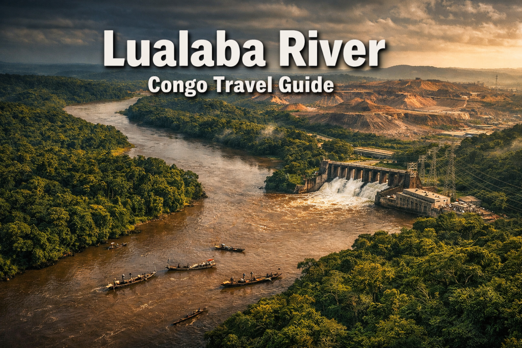
The Lualaba River Congo is the upper section of the Congo River system, flowing approximately 1,800 kilometers through southeastern Democratic Republic of Congo from its source near the Zambian border through Katanga and Lualaba provinces before joining the Luvua River to form the main Congo River. The river passes through copper-rich mining regions including Kolwezi and serves as a transport corridor, fishing ground, and location for hydropower development projects including the 200 MW Nzilo 2 plant scheduled for 2029 completion. Visitors traveling to Lualaba province for mining industry tours, conservation work, or regional exploration will cross or follow sections of this river system.
The Lualaba River forms the headwaters of the Congo River system in southeastern DRC. The river flows through Lualaba and Haut-Katanga provinces, passing major mining centers and supporting local fishing communities. Access requires coordination with mining operators or regional tour companies based in Kolwezi or Lubumbashi. The river is not a wildlife tourism destination but serves as a geographic reference point for visitors to the Copperbelt region. Hydropower projects and mining infrastructure dominate the riverbanks in developed sections.
The Lualaba River Congo runs through the southeastern Democratic Republic of Congo, primarily in Lualaba and Haut-Katanga provinces. The river supports artisanal fishing, serves as a transport route for mining supplies, and hosts hydropower infrastructure. Visitors typically encounter the river when traveling between mining towns or crossing on National Road 2. Tourism infrastructure remains limited, with access arranged through mining companies, development project coordinators, or specialized regional tour operators.
Lualaba River Congo Location and Geography
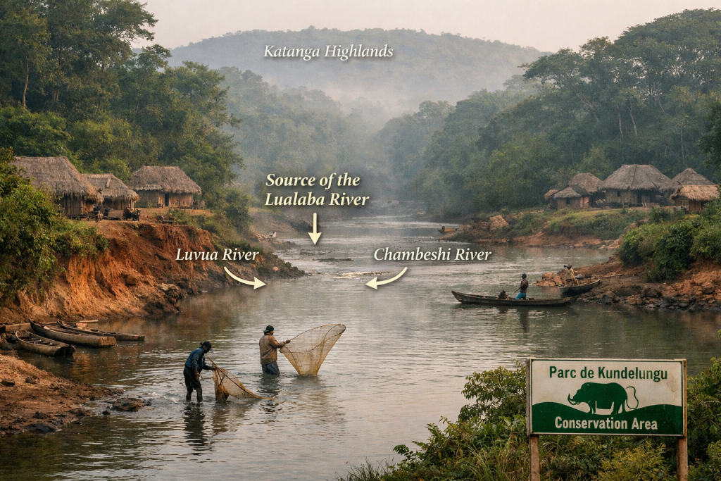
The Lualaba River originates near the town of Musofi in Haut-Katanga province, close to the border with Zambia. The river flows northward through the Katanga plateau region for approximately 1,800 kilometers before merging with the Luvua River to form the Congo River proper near Kisangani.
The river passes through Lualaba province, which has a population exceeding 3 million people. Major towns along the river corridor include Kolwezi, a significant copper and cobalt mining center located approximately 60 kilometers from the Nzilo 2 hydropower construction site.
The river basin encompasses areas of tropical rainforest, degraded forest zones affected by mining operations, and grassland savannah. Between 2001 and 2024, Lualaba and Haut-Katanga provinces lost 1.38 million hectares of tree cover primarily due to mining activities. The riverbanks in mining zones show visible erosion and altered vegetation patterns.
Lualaba River Congo Access and Transport Routes
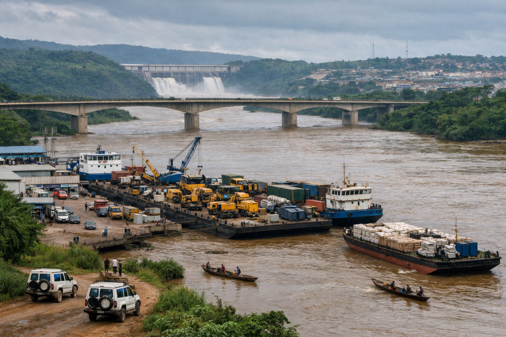
Visitors reach sections of the Lualaba River by road from Lubumbashi or Kolwezi. National Road 2 (RN2) crosses the river and connects mining centers in the region. A 200-kilometer stretch of RN2 between Mbanga and the Lualaba River is undergoing climate-resilient upgrades including reinforced culverts and bioengineered slopes.
Road conditions vary significantly by season. The dry season from May to September offers better accessibility, while the rainy season from November to March can make unpaved sections impassable. Travel requires 4×4 vehicles with experienced drivers familiar with regional road conditions.
Charter flights to Kolwezi Airport provide access to the Lualaba River region for visitors with limited time. From Kolwezi, ground transport to river crossing points takes between one and three hours depending on destination and road conditions.
Most river access points are controlled by mining companies or located within concession areas. Visitors require advance permission and coordination with operators or local authorities. Independent access to riverbanks is restricted in many developed sections.
Lualaba River Congo Hydropower Development Projects
The Nzilo 2 hydropower plant represents a major infrastructure project on the Lualaba River system. The 200 MW facility is targeted for commissioning by early 2029, with construction located approximately 60 kilometers from Kolwezi. The project cost exceeds $470 million, jointly financed by Mining Engineering Services (MES) and China Molybdenum Company Limited (CMOC).
The plant will feature four 50 MW turbines and include a solar component to complement hydropower generation. As of October 2025, work remained in the preparatory phase, including construction of access roads and a river diversion tunnel. Visitors interested in development projects can arrange site visits through official channels, though access is restricted to authorized personnel during construction.
Hydropower projects in the region total nearly 1,000 MW capacity, addressing a national electricity deficit estimated at 3,000 MW. The Lualaba River’s hydroelectric potential attracts ongoing investment in power generation infrastructure.
Existing dams and planned facilities alter river flow patterns and create reservoir areas. These changes affect traditional fishing zones and require local communities to adapt access patterns and resource use practices.
Lualaba River Congo Mining Industry Context
The Lualaba River flows through the heart of the Congolese Copperbelt, one of the world’s most concentrated copper and cobalt production zones. Lualaba province positions itself as a strategic hub for mining, energy, and logistics, targeting establishment as a regional center by 2030.
Mining operations dominate the landscape along many river sections. Tailings facilities, processing plants, and transport infrastructure occupy riverbank areas. Water use for mineral processing and dust suppression creates demand on river resources.
Private sector representatives confirm that developing additional copper production capacity in the DRC remains more attractive than other jurisdictions in terms of dollars invested per installed tonne. This investment climate drives continued expansion of mining infrastructure near the river.
Visitors to the region for mining industry tours, investment assessment, or technical work will encounter the river as a geographic feature within the broader mining landscape. The river does not function as a tourist attraction but serves as a reference point for navigation and regional orientation.
Lualaba River Congo Community Forest Protection Areas
Haut-Katanga province maintains 20 community forest concessions covering 239,000 hectares, though these face obstacles including mining licenses issued without proper community consent. Community forests along the Lualaba River corridor provide local resource management zones.
Forest protection efforts contend with pressure from mining expansion, artisanal extraction, and agricultural clearing. Between 2001 and 2024, forest loss in the region totaled 1.38 million hectares[5]. Community forest concessions attempt to balance conservation with local livelihood needs.
Visitors working with conservation organizations or community development projects may access forest areas along the river through coordinated arrangements with local authorities and community representatives. These visits require advance planning, local guides, and respect for community protocols.
Forest areas support subsistence hunting, fishing, and gathering activities. Visitors should not expect wildlife tourism infrastructure or game viewing opportunities comparable to established national parks in other African regions.
Lualaba River Congo Fishing and Local Resource Use
Artisanal fishing provides protein and income for communities along the Lualaba River. Fishermen use traditional canoes, nets, and traps to harvest fish species adapted to the river’s brown, sediment-laden waters. Fishing activity increases during low water periods when fish concentrate in accessible channels.
Local markets in riverside towns sell fresh and smoked fish caught from the river. Fish species include catfish varieties, tilapia, and other freshwater species. Commercial fishing operations remain limited compared to subsistence and small-scale commercial activity.
Mining pollution, sedimentation, and altered flow patterns from dam construction affect fish populations and fishing success rates. Communities adapt fishing locations and methods in response to changing river conditions.
Visitors interested in local fishing practices can observe activity from riverbanks or arrange boat trips with local fishermen through community contacts. These experiences require local language skills or interpreter assistance and advance coordination with community leaders.
Lualaba River Congo Regional Development and Infrastructure
Lualaba province aims to establish itself at the intersection of regional economic corridors including SADC, COMESA, and EAC by 2030. This positioning strategy involves transport infrastructure development, energy projects, and logistics capacity expansion.
The RN2 highway upgrade between Mbanga and the Lualaba River includes climate-resilient features to maintain year-round accessibility. Improved road infrastructure supports mining operations, regional trade, and limited tourism movement through the area.
Port facilities along the river handle cargo including mining equipment, fuel, and supplies. River transport complements road and air freight for moving heavy or bulk materials. Passenger transport on the river remains limited to local canoe traffic and occasional chartered boats.
Visitors traveling through the region will encounter development projects, construction sites, and industrial infrastructure. The landscape reflects active economic development rather than preserved natural environments or traditional cultural settings.
Lualaba River Congo Travel Planning and Logistics
Travel to the Lualaba River region requires careful planning and realistic expectations. Visitors should arrange transport, accommodation, and local coordination through established operators familiar with regional conditions. Independent travel presents significant logistical challenges.
Kolwezi and Lubumbashi serve as base cities for accessing the Lualaba River area. Accommodation options in these cities range from international standard hotels to basic guesthouses. Riverbank accommodation is limited to mining camp facilities or community housing arranged through local contacts.
Visitors require valid DRC visas, yellow fever vaccination certificates, and malaria prophylaxis. Travel insurance should cover medical evacuation, as healthcare facilities in the region offer limited services. Security conditions vary, and visitors should consult current travel advisories.
Local tour operators and mining industry coordinators can arrange river crossings, site visits, and transport logistics. These services require advance booking and clear communication of requirements and limitations.
Lualaba River Congo Seasonal Conditions and Best Travel Times
The dry season from May to September offers the most reliable travel conditions for accessing the Lualaba River region. Roads remain more passable, river levels stabilize, and mining operations maintain regular schedules. Temperatures during this period range from 15 to 28 degrees Celsius.
The rainy season from November to March brings heavy precipitation, flooding, and difficult road conditions. River levels rise significantly, altering fishing patterns and transport options. Some roads become impassable, restricting access to remote river sections.
The transitional months of April and October present variable conditions. Early rains can begin in October, while April may still experience wet weather. Visitors with flexible schedules can sometimes benefit from lower activity levels during these shoulder periods.
Mining operations and development projects continue year-round, so visitors on business or technical assignments should plan according to project schedules rather than optimal travel seasons. Rainy season travel requires additional contingency time and flexible itineraries.
Lualaba River Congo Wildlife and Natural Environment
The Lualaba River corridor does not function as a wildlife tourism destination. Forest loss, mining activity, and human settlement have reduced wildlife populations in accessible areas. Visitors should not expect game viewing opportunities or encounters with large mammals.
Bird species adapted to riverine and disturbed habitats occur along the river. Wading birds, kingfishers, and waterfowl can be observed from riverbanks or boats. Serious birding requires local guides familiar with species identification and seasonal patterns.
Aquatic life includes fish species harvested by local communities and smaller organisms adapted to the river’s conditions. Water quality varies significantly depending on location relative to mining operations and urban centers.
Vegetation along the river includes remnant forest patches, regenerating secondary growth, and planted trees in community areas. The natural environment shows clear signs of human modification and resource extraction.
Lualaba River Congo Photography and Documentation
Photographers visiting the Lualaba River region should focus on documentary subjects including infrastructure development, mining operations, community life, and environmental conditions. The river serves as a backdrop or contextual element rather than a primary photographic subject.
Permission is required for photographing mining facilities, hydropower projects, and military or government installations. Visitors should obtain written authorization before attempting to document industrial sites or infrastructure.
Community photography requires respectful engagement and permission from individuals and local leaders. Offering to share images or provide copies builds positive relationships. Commercial use of images depicting identifiable people requires model releases.
Equipment should include weather protection for cameras and lenses, as dust and humidity affect gear performance. Backup storage and power solutions are necessary, as charging opportunities may be limited in remote areas.
FAQ About Lualaba River Congo Travel
Can tourists visit the Lualaba River independently?
Independent tourism to the Lualaba River is not practical. The region lacks tourist infrastructure, and most river access points fall within mining concessions or restricted areas. Visitors require coordination with mining companies, development projects, or specialized regional operators.
What wildlife can be seen along the Lualaba River?
The Lualaba River corridor is not a wildlife viewing destination. Mining activity and forest loss have reduced animal populations. Bird species occur along the river, but large mammal sightings are rare in accessible areas.
Is the Lualaba River safe for swimming or water activities?
Swimming in the Lualaba River is not recommended due to water quality concerns, strong currents, and potential health risks. The river carries sediment and receives runoff from mining operations and urban areas.
What permits are needed to visit the Lualaba River region?
Visitors require valid DRC visas and yellow fever vaccination certificates. Access to specific river sections may require additional permissions from mining companies, local authorities, or project coordinators depending on location and purpose.
How long does it take to reach the Lualaba River from Lubumbashi?
Travel time from Lubumbashi to Lualaba River crossing points ranges from four to eight hours by road depending on destination, road conditions, and season. Charter flights to Kolwezi reduce travel time significantly.
Are there accommodation options near the Lualaba River?
Accommodation near the river is limited to mining camps and basic community facilities. Visitors typically stay in Kolwezi or Lubumbashi and travel to river locations for day visits or short trips.
What is the best time of year to visit the Lualaba River region?
The dry season from May to September offers the most reliable travel conditions. Roads are more passable, and river levels are stable. Rainy season travel from November to March presents significant logistical challenges.
Can visitors take boat trips on the Lualaba River?
Boat trips can be arranged through local fishermen or project coordinators in specific locations. Regular passenger boat services do not operate. Safety equipment and experienced boat operators are necessary.
What languages are spoken in the Lualaba River region?
French serves as the official language. Local languages include Swahili, Luba-Katanga, and other regional dialects. English is rarely spoken outside international mining operations.
Is the Lualaba River the same as the Congo River?
The Lualaba River is the upper section of the Congo River system. It becomes the Congo River after joining the Luvua River near Kisangani. The name Lualaba applies to the southeastern section flowing through Katanga and Lualaba provinces.
Key Takeaways
The Lualaba River Congo flows through southeastern DRC, primarily in Lualaba and Haut-Katanga provinces. The river passes through the Congolese Copperbelt, one of the world’s major copper and cobalt production zones. Hydropower development includes the 200 MW Nzilo 2 plant targeted for 2029 completion. Access requires coordination with mining operators or regional tour companies based in Kolwezi or Lubumbashi.
The river is not a wildlife tourism destination but serves as a geographic reference for visitors to the mining region. Road access via National Road 2 is most reliable during the dry season from May to September. Community forest concessions cover 239,000 hectares in Haut-Katanga province despite pressure from mining expansion. Artisanal fishing provides local livelihoods along accessible river sections.
Travel planning requires realistic expectations about infrastructure, accommodation, and access limitations. Visitors typically travel for mining industry work, development projects, or specialized regional exploration rather than conventional tourism. The landscape reflects active economic development and resource extraction rather than preserved natural environments.